Customers
Hammers has a long history providing guidance, navigation, and attitude control analysis, algorithm design, development, validation, verification, and simulations. We also provide support for spacecraft integration and test (I&T) and mission operations development, testing, and maintenance. Hammers develops and maintains ground systems to support component, instrument, and spacecraft development, I&T, and mission operations.
Hammers is the prime contractor for the LDCM (now Landsat-8) Mission Operations Element (MOE). The MOE provides telemetry and command, mission planning, trending, flight dynamics, and operations automation. As the prime contractor, our company has demonstrated the ability to manage a ground system development activity for a Class 1 NASA mission with three major subcontractors including General Dynamics Mission Systems. We provide contract, schedule, financial and risk management in addition to developing, integrating, testing and delivering software and hardware systems to support the current Landsat 8 mission.
NASA GSFC
Jet Propulsion Laboratory (JPL)
Naval Research Laboratory
The James Webb Space Telescope
The James Webb Space Telescope US contributor list. View the Hammers Company under Greenbelt, MD.
The James Webb Space Telescope (sometimes called JWST or Webb) will be a large infrared telescope with a 6.5-meter primary mirror. The telescope will be launched on an Ariane 5 rocket from French Guiana in 2021.
Webb will be the premier observatory of the next decade, serving thousands of astronomers worldwide. It will study every phase in the history of our Universe, ranging from the first luminous glows after the Big Bang, to the formation of solar systems capable of supporting life on planets like Earth, to the evolution of our own Solar System.
Webb was formerly known as the "Next Generation Space Telescope" (NGST); it was renamed in Sept. 2002 after a former NASA administrator, James Webb.
Lunar Atmosphere and Dust Environment Explorer 2010-present
LADEE Satellite orbiting the moon.
The Lunar Atmosphere and Dust Environment Explorer (LADEE) is designed to study the Moon’s this exosphere and the lunar dust environment. The orbiter will determine the density, composition and temporal and spatial variability of the Moon’s exosphere to help us understand where the species in the exosphere came from as well as the role of the solar wind, lunar surface and interior, and meteoric infall as sources. The mission will also examine the density and temporal and spatial variability of dust particles that may get lofted into the atmosphere. Because the Moon’s atmosphere is so thin, disturbances could quickly swamp its natural composition.
The mission will also test several new technologies, including a modular spacecraft bus that may reduce the cost of future deep space missions and demonstrate two-way high rate laser communication for the first time from the Moon.
In addition to supporting the ITOS system as the standard TT&C for all Integration and Test, Mission, Science and LaserComm Operations
Provided Ground Systems Engineering support to the MOC and I&T.
Lunar Reconnaissance Orbiter (LRO) 2006-present

The Lunar Reconnaissance Orbiter (LRO) is a robotic mission that set out to map the moon’s surface and, after a year of exploration was extended with a unique set of science objectives. LRO observations have enabled numerous groundbreaking discoveries, creating a new picture of the Moon as a dynamic and complex body. These developments have set up a scientific framework through which to challenge and improve our understanding of processes throughout the solar system.
The LRO instruments return global data, such as day-night temperature maps, a global geodetic grid, high resolution color imaging and the Moon’s UV albedo. There is particular emphasis on the polar regions of the Moon where continuous access to solar illumination may be possible and the prospect of water in the permanently shadowed regions at the poles may exist.
Hammers was the developer of the flight software for this mission, including attitude, determination & Control (ACS) and command and Data handling (CD&H) in real-time. Additionally, Hammers developed the ground software command and telemetry System. For the LRO mission, Hammers designed and delivered 18 spacecraft simulators with MIL STD 1553 and SpaceWire data interfaces for the mission team. We also served in a lead role on the Ground System Refresh and virtualization effort that began in 2012.
USGS Landsat 8

Landsat represents the world’s longer continuously acquired collection of space-based moderate-resolution land remote sensing data. Four decades of imagery provided a unique resource for those who work in agriculture, geology, forestry, regional planning, education, mapping, and global change research. Landsat images have proven invaluable for emergency response and disaster relief. As a joint initiative between the U.S. geological Survey (USGS) and NASA, the Landsat Project and the data it collects support government, commercial, industrial, civilian, military, and educational communities throughout the United States and worldwide. The Landsat 8 satellite images the entire Earth every 16 days in an 8-day offset from Landsat 7.
The Landsat 8 OLI/TIRS Pre-WRS-2 data set contains nearly 10,000 scenes acquired by the Operational Land Imager (OLI) and/or Thermal Infrared Sensor (TIRS) sensors after launch (February 11, 2013) through April 10, 2013, the satellite achieved operational orbit (WRS-2).
Hammers designed and implemented the Mission Operations Element (MOE) for this first class NASA mission. The system incorporates the latest technology in virtual servers for Telemetry and Command, Flight Dynamics, Planning and Scheduling, and System Automation.
NASA Fermi (GLAST)

Numerous exotic phenomena occur in space and some of these can generate almost inconceivable amounts of energy. Some of these phenomena include, supermassive black holes, merging neutron stars, and streams of hot gas moving at the speed of light. The Fermi Gamma-ray Space Telescope, formerly GLAST, is opening the high-energy world of space to exploration and helping to answer important questions. Questions including, what is happening to produce the amount of energy, what happens to the surrounding environment near those phenomena, and how will studying the energetic objects ass to the understanding of the nature of the universe and how it behaves.
With Fermi, astronauts can finally have a tool to study how black holes, known for pulling matter in, can accelerate jets of gas outward at extremely high speeds. Physicists are able to study subatomic particles at energies far greater than those seen in ground-based particle accelerators. And cosmologists are gaining valuable information about the birth and early evolution of the Universe. For this endeavor, one that brings together the astrophysics and particle physics communities, NASA has teamed with the U.S. Department of Energy and Institutions in France, Germany, Japan, Italy, and Sweden.
NASA THEMIS/ARTEMIS

The Time History of Events and Macroscale Interactions during Substorms (THEMIS) is a mission to investigate what causes auras in the Earth’s atmosphere to dramatically change from slowly shimmering waves of light to wildly shifting streaks of color. Discovering what causes auroras to change will provide scientists with important details on how the planet’s magnetosphere works and the important Sun-Earth connection.
Themis is a 2 year mission consisting of 5 identical probes that will study the violent colorful eruptions or Auroras. Understanding and predicting the weather is important to describe the environment in which spacecraft and astronauts operate and ensure their safety. Just as hail and tornadoes accompany the most severe thunderstorms, substorms accompany the most intense space storms; those that disrupt communications, cause power line transmission failures, and produce the most penetrating radiation. THEMIS will study substorms to gain insight into the most severe space storms. With THEMIS, for the first time NASA will launch a constellation of five satellites to study substorms.
The Hammers Company designed, developed, integrated and tested the flight software which included the attitude control and command and data handling on-board systems. Hammers also used our ITOS command and control system for spacecraft integration and test, launch and early orbit operations and is the mission operations system for the constellation. As part of continued real-time operations support, Hammers flight software engineers developed and uploaded new control algorithms in two of the spacecraft to move them into a lunar orbit for the ARTEMIS mission requirements.
NASA Swift

SWIFT is a MIDEX Gamma Ray Burst mission led by NASA with participation of Italy and the UK. SWIFT is a mission that was dedicated to the observations of Gamma-ray bursts (GRBs), although, throughout the life of this mission a lot of challenging non-GRB science has been performed. GRBs are the most powerful explosions the Universe has seen since the Big Bang, occurring about once a day. They are brief, but intense flashes of gamma radiation, coming from all different directions of the sky and last from a few milliseconds to a few hundred seconds. To date, scientists do not know what causes them.
With SWIFT, launched in November 2004, scientists now have a tool dedicated to answering the many questions and solving the gamma-ray burst mystery. SWIFT relays a burst’s location to ground stations within seconds after the burst onset, allowing both ground-based and space-based telescopes around the world the opportunity to observe the burst’s afterglow. The instruments are on board SWIFT include the Burst Alert Telescope (BAT), the X-Ray Telescope (XRT), and the Ultra Violet-Optical Telescope (UVOT).
Hammers provided VirtualSat® to support operations for slow commanding to institute science observations.
NASA ICESAT-2

ICESat-2 is a continuation of the global time series of precision ice topography measurements initiated but the first ICESat mission. It has been extended in selected areas by the IceBridge projects, a series of ongoing surveys of polar areas using aircraft-borne instruments. The first ICESat was on orbit from 2003-2010, and provided invaluable data needed to assess ice sheet mass balance, sea ice thickness, and to estimate biomass.
ICESat -2 will use improved precision laser-ranging techniques to measure the topography of the Greenland and Antarctic ice sheets and the thickness of sea ice. ICESat-2 will help scientists develop a better scientific understanding of the Earth system and its response to natural or human-induced changes.
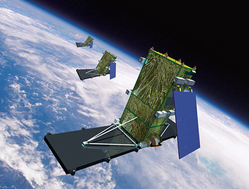
NASA CYGNSS

he Cyclone Global Navigation Satellite System (CYGNSS) aims to improve extreme weather prediction. This project uses a constellation of eight satellites carried into orbit on a single launch vehicle. While in orbit, CYGNSS’s eight micro-satellite observatories will receive both direct and reflected signals from Global positioning System (GPS) satellites. The direct signals pinpoint CYGNSS observatory positions, while the reflected signals respond to ocean surface roughness which is received from wind speed.
This mission of CYGNSS is to study the relationship between ocean surface properties, moist atmospheric thermodynamics, radiation and convective dynamics to determine how a tropical cyclone forms and whether or not it will strengthen, and if so, by how much. This data will advance forecasting and tracking methods.
The satellites are expected to launch in 2016.
NASA ICON
The Ionospheric Connection Explorer will explore the boundary between Earth and space, the ionosphere, in order to understand the physical connection between our world and the immediate space environment around us. In this region, where ionized plasma and neutral gas collide and react, exhibits dramatic variability that affects space-based technological systems like GPS. The ionosphere has been known to respond to “space weather” drivers from the sun, but recent NASA missions have shown this variability often occurs in connection with weather on our planet. ICON will compare the impacts of these two drivers as they exert change on the space environment that surrounds us.
NASA SAMPEX

The Solar Anomalous and Magnetospheric Particle Explorer (SAMPEX) was an international collaboration between NASA of the United Stated and Germany. It was the first of SMEX’es (Small Explorers), and was launched in July 1992, carrying four instruments and aimed to fly in low orbits. SAMPEX studies the energy, composition, and charge states of particles from supernova explosions, from the heart of solar flares, and from the depths of nearby interstellar space. It also closely monitors the magnetospheric particle populations which sometimes drop into the middle atmosphere of the Earth, thereby ionizing neutral gases and altering the atmospheric chemistry. One of the key elements of SAMPEX is to use the magnetic field of the earth as an essential component of the measurement strategy.
Over the next several years, as the solar activity ramps up to its 11-year maximum, SAMPEX investigations will survey the acceleration of the relativistic electrons, measure their impact on the upper atmosphere, and determine their influence on atmospheric chemistry not only for solar minimum conditions but also for the more complex solar active periods; obtain samples of solar material from dozens of flares; measure the anomalous component isotrophic composition, trapping lifetime, and disappearance near solar maximum; and to serve as a unique link in the chain of observatories put in place by NASA and its international partners to study space weather during upcoming solar maximum. Most of these investigations can only be carried out using SAMPEX’s unique orbit and highly sensitive detectors.
As part of the NASA Small Explorer (SMEX) team, Hammers supported development of the flight software for attitude control and the command and data handling systems. Utilizing the ITOS command and control ground system, Hammers supported spacecraft integration and test, launch and early orbit mission operations.
NASA FAST

Fast Auroral Snapshot Explorer (FAST) is the second of the Small-Call Explorer (SMEX) missions. FAST will investigate the plasma physics of the auroral phenomena which occur around both of the Earth’s poles. In order to complete this investigation, high data rate snapshots will be taken with electric and magnetic field sensors and plasma particle instruments, while traversing through the auroral regions.
The scientific instruments on board FAST include energetic electron and ion electrostatic analyzers, an energetic ion instrument that distinguishes ion mass, and vector DC wave electric and magnetic field instruments. A state-of-the-art flight computer includes programmable processors that trigger th burst data collection when interesting physical phenomena are encountered and stores these data in a 1Gbit solid-state memory for telemetry to the Earth at later times.
FAST was launched in August 1996.
As part of the NASA Small Explorer (SMEX) team, Hammers supported development of the flight software for attitude control and the command and data handling systems. Utilizing the ITOS command and control ground system, Hammers supported spacecraft integration and test, launch and early orbit mission operations.
NASA SWAS

The Submillimeter Wave Astronomy Satellite (SWAS) was launched in December 1998 into a low Earth orbit. This was a part of the Small Explorer (SMEX) mission and was originally planned for two years, but SWAS made observations until July 2004. The goal of this mission was to gain a greater understanding of star formation by determining the composition of interstellar clouds and establishing the means by which these clouds cool as they collapse to form stars and planets.
After over six years of science observations, SWAS achieved and exceeded its original goals. It made detailed maps of many giant molecular and dark cloud cores, it observed the atmospheres of Mars, Jupiter, Saturn and several comets, and made other key discoveries. One of these discoveries is that water is prevalent throughout space, it was detected in almost every dust cloud in space it observed.
As part of the NASA Small Explorer (SMEX) team, Hammers supported development of the flight software for attitude control and the command and data handling systems. Utilizing the ITOS command and control ground system, Hammers supported spacecraft integration and test, launch and early orbit mission operations.
NASA TRACE

The Transition Region and Coronal Explorer was launched in April 1998, with the objective to explore the three-dimensional magnetic structures which emerge through the visible surface of the Sun and define the geometry and dynamics of the upper solar atmosphere. The TRACE data provided quantitative observational constraints on the models, leading to real advances in our understanding of the transition from low to high beta plasma. The solar atmosphere is constantly evolving because the magnetic field which dominate the Corona are continuously being displaced by the convective motions in the outer layers of the Sun just below the Photosphere. One of the major objectives of the TRACE investigation was to explore the relation between diffusion on the surface magnetic fields and the changes in heating structure throughout the Transition Region and Corona. The simultaneous movies of the 6000 to 10,000 degrees K volume of the solar atmosphere allowed us to determine the rate of change of the magnetic topology and the nature of the local restructuring and reconnection processes.
As part of the NASA Small Explorer (SMEX) team, Hammers supported development of the flight software for attitude control and the command and data handling systems. Utilizing the ITOS command and control ground system, Hammers supported spacecraft integration and test, launch and early orbit mission operations.
NASA WIRE

The Wide-field Infrared Explorer (WIRE) was a small satellite carrying cryogenically cooled infrared telescope designed to study starburst galaxies, vast clouds of molecular gas around the sites of newborn starts. WIRE was developed under NASA’s Small Explorer Program (SMEX) and was launched in March 1999. Due to an equipment malfunction, the telescope’s coolant was delpleted quickly shortly after its launch, thus it was unusable for its original mission. WIRE has since been repurposed to use on onboard Star Tracker for long-term monitoring of bright stars.
As part of the NASA Small Explorer (SMEX) team, Hammers supported development of the flight software for attitude control and the command and data handling systems. Utilizing the ITOS command and control ground system, Hammers supported spacecraft integration and test, launch and early orbit mission operations.
NASA Laser Communications Relay Demonstration

The Laser Communications Relay Demonstration (LCRD) is a NASA mission to use laser light to transfer data from orbit to ground and all around the solar system. When launched, the satellite will be positioned above the equator, which is a prime location for line-of-sight to other orbiting satellites and ground stations. Space laser communications technology has the potential to provide 10 to 100 times higher data rates than traditional radio frequency systems for the same mass and power. LCRD is scheduled to be launched in 2017.
NASA RHESSI

The Rueven Ramaty High Energy Solar Spectroscope Imager (RHESSI) was launched in February 2002, with the primary scientific objective of understanding various processes that take place in the magnetized plasmas of the solar atmosphere during a flare. The specific processes it aims to study are impulsive energy release, particle acceleration, and particle and energy transport. These high-energy processes play a major role at sites throughout the universe ranging from magnetospheres to active galaxies. Consequently, the importance of understanding these processes transcends the field of solar physics.
NASA NuSTAR
The Nuclear Spectroscope Telescope array (NuSTAR) is an Explorer mission that aims to allow astronauts to study the universe in high energy X-ryas. Launched in June of 2012, NuSTAR is the first focusing hard x-ray telescope to orbit Earth. NuSTARs primary science objectives include conducting a census for black holes on all scales using wide-field surveys of extragalactic fields and Galactic center, mapping radioactive material in young supernova remnants, and observing relativistic jets found in the most extreme active galaxies and to understand what powers giant cosmic accelerators. NuSTAR will also perform follow-up observations to discoveries made by Chandra and Spitzer, and will team with FERMI, making simultaneous observations which will enhance FERMI’s science data.
Utilizing the ITOS command and control ground system, Hammers supported spacecraft integration and test, launch and early orbit mission operations.
NASA IRIS

The Interface Region Imaging Spectrograph (IRIS) mission opens a window of discovery into the crucial region of the interface between the photosphere and corona. The means in which IRIS carries this out is through tracing the flow of energy and plasma through the chromospheres and transition region into the corona using spectrometry and imaging. Iris is designed to provide significant new information to increase the understanding of energy transport into the corona and solar wind and to provide an archetype for all stellar atmospheres. Through the specialized instruments on board, IRIS’ 3-D modeling will fill a large gap in the knowledge of this dynamic region.
The IRIS science investigation is centered around themes of broad significance to solar and plasma physics, space weather, and astrophysics, with an aim of understanding how internal convection flows power atmospheric activity. IRIS was launched in April of 2013.
CSA SCISAT-1

SCISAT -1 is a mission that was developed by the Canadian Space Agency, designed to make observations of the Earth’s atmosphere. The primary instrument on board is an optical spectrometer which records the spectrum of the Sun, as sunlight passes through the Earth’s atmosphere. Astronomers use planetary occultations, which occur when a planet passed in front of a star to determine the structure of the planet’s atmosphere. SCISAT-1 will use the occultation of the Sun, by the Earth, to make detailed observations of the structure and chemistry of that part of the Earth’s atmosphere.
CSA Cassiope

Cassiope, CAScade, Smallsat and Ionospheric Polar Explorer, is a Candian Space Agency multi-mission satellite, and was launched in September 2013. CASSIOPE is the first Canadian hybrid satellite to carry a dual mission in the fields of telecommunications and scientific research. The main objectives of this mission are to gather information to better understand the science of space weather, while verifying high speed communications concepts through the use of advances space technologies. The satellite was deployed in an elliptical polar orbit and a carries commercial systems, Cascade, and a scientific experiment package called e-POP.
CSA NEOSSat

The Near-Earth Object Surveillance Satellite (NESSAT) was launched in February 2013, and is a member of the Canadian Space Agency satellites. NEOSSAT is the world’s first space telescope dedicated to detecting and tracking asteroids and satellites. Every 100 minutes, it makes a circle around the globe, scanning space near the sun to pinpoint asteroids that may pass to close to Earth. Additionally, it is sweeping the skies in search of satellites and space debris.
The hundreds of images that NEOSSAT will generate every day will be downloaded and analyzed by the University of Calgary’s NEOSSat science operations center. The data generated through NEOSSat will assist in the international effort to catalogue the near-Earth population of asteroids, thus producing information that will be crucial to targeting new destinations for future space exploration.
CSA RADARSAT Constellation Mission
The RADARSAT Constellation Mission (RCM) is a Government of Canada mission. It consists of a three spacecraft fleet of Earth observation satellites. The RCM will provide new applications, which has been made possible through the constellation approach, as well as continuing to provide C band radar data to RADARSAT-2 users. The improvements to this mission are the increased area coverage of Canada and the reduced risk of a service interruption. Government and commercial applications for this mission, in broad terms, include national security, resource management, sustainable development, and transportation. The launch of the RADARSAT Constellation is scheduled for 2018.
Defense R&D Canada’s M3MSat

The Maritime Monitoring and Messaging Micro-Satellite (M3MSat) is being built by Canada, and is scheduled to launch in 2014. M3MSat will be able to process data from the marine self-configuring network implemented by the International Maritime Organization through the United Nations. As big as a medium-sized moving box, the M3MSat will use a new type of generic satellite platform, and will orbit at an altitude of about 650 Km above Earth. Traveling over all Canadian waters approximately ten times a day, this project is an advance to the monitoring of Canadian waters, as its position above Earth will allow if to cover a much larger areas than ground sensors to capture AIS signals.
The M3MSat microsatellite will be used to receive and locate digital signals transmitted by vessels. This data will be sent to ground stations to then be relayed to operators for Defense Research and Development Canada. This will make it possible to identify and record marine traffic, know vessels’ directions and cruising speed and ensure that they navigate legally and safely in Canadian waters.
NASA/NOAA DSCOVR

The Deep Space Climate Observatory (DSCOVR) project is a NOAA Earth observation and solar weather satellite scheduled to be launched in early 2015. This was originally a NASA satellite proposed in 1998. The intended position of the satellite id a the Sun-Earth Lagrangian point; this location will allow it to have a continuous view of the sun and the sunlit side of the Earth, with the hopes to provide early warning of approaching solar storms. The primary operations objective of the DSCOVR mission is to provide solar wind thermal plasma and magnetic field measurements to enable space weather forecasting by NOAA. The secondary science objectives are to image the sun lit disk of the Earth in bands to determine ozone, aerosol, cloud cover, cloud heights, vegetation, and leaf area indices and to measure the Earth reflected irradiance in the wavelength range of 0.2-100 microns.
NASA WIND

WIND is a spin stabilized spacecraft that was launched in November 1994, meant to observe the unperturbed solar wind that is about to impact the magnetosphere of Earth. In collaboration with Geotail, Polar, SoHo and Cluster, these satellites constitute a cooperative scientific satellite project, called the International Solar Terrestrial Physics (ISTP) project. The aim of the ISTP project is to gain improved understanding of the physics of solar terrestrial relations.
NASA ACE missions

Launched in August 1997, the Advanced Composition Explorer (ACE) observes particles of solar, interplanetary, interstellar, and galactic origin, spanning the energy range from solar wind ions to galactic cosmic ray nuclei. ACE provides near real-time solar wind information over short periods of time. When reporting space weather, ACE can provide an advance warning of geomagnetic storms that can overload power grids, disrupt communications on Earth, and present a hazard to astronauts.
The prime objective of ACE is to measure and compare the composition of several samples of matter, including the solar corona, the solar wind, and other interplanetary particle populations, the local interstellar medium, and galactic matter.
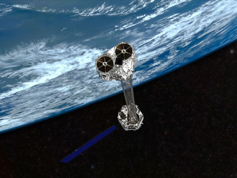
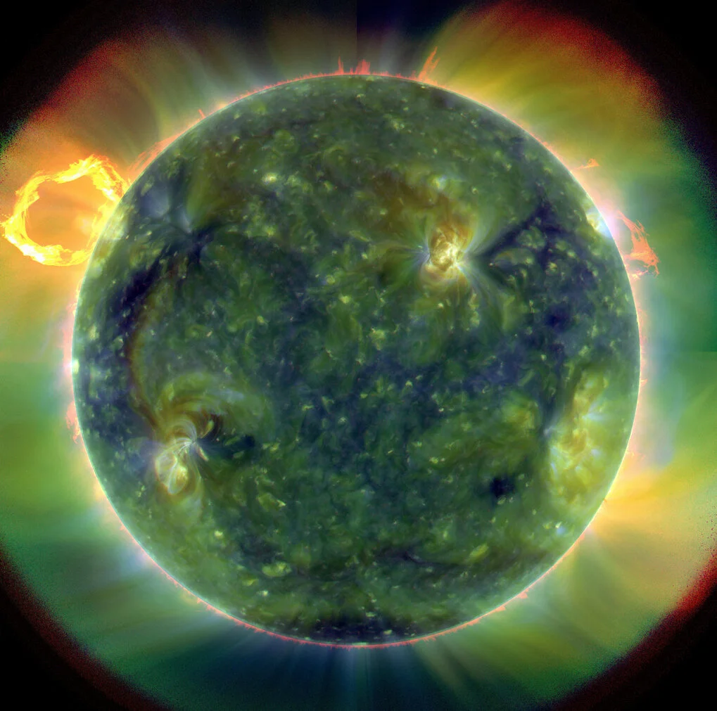
NRL’s SECCHI instrument for the STEREO mission

SECCHI is a suite of remote sensing instruments that consists of two white light coronagraphs and an EUV imager. These instruments are referred to as the Sun Centered Imaging Package and a Heliospheric Imager. SECCHI will follow three-dimensional Coronal Mass Ejections (CMEs) from birth, at the Sun’s surface, through the corona and interplanetary medium, to the impact at Earth. The anticipation of this mission are breakthroughs in understanding the origin and consequence of CMEs, in determining their three-dimensional structure, in identifying the magnetic configurations and evolutionary paths leading to CMEs, in determining the key factors controlling their trajectories, and in achieving the national goal of predicting space weather.
Joint Polar Satellite System (JPSS)

JPSS (Joint Polar Satellite System) is a NOAA and NASA collaboration project. JPSS-1 was launched in October 2011, and JPSS-2 will be launched in 2017. JPSS represents significant technological and scientific advances in environmental monitoring and will help to advance weather, climate, environmental and oceanographic sciences. It will provide operational continuity of satellite based observations and products for NOAA Polar-Orbiting Operational Environment Satellites and the Suomi National Polar-orbiting Partnership. NOAA is responsible for managing and operating the JPSS program, which NASA is responsible for developing and building the JPSS spacecraft. To date, JPSS is the only viable national satellite program currently in production that ensures continuity of observational data at the quality levels needed to sustain current weather forecasts beyond 2017.
NASA Morpheus
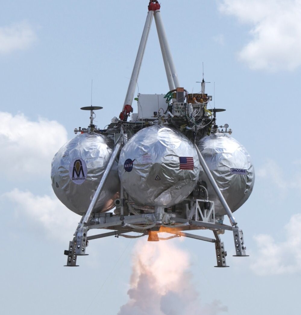
Project Morpheus is a NASA project to develop a vertical takeoff and vertical landing test vehicle, called Morpheus Lander, in order to demonstrate a new, non-toxic spacecraft propellant system and an autonomous landing and hazard detection system. The vehicles are NASA designed robotic landers that will be able to land and takeoff with 1,100 pounds of cargo on the moon. The projection is an engine that runs reliably on propellants that are cheaper and safer on Earth and can potentially be manufactured on the Moon.
NRL’s SoloHI instrument for the ESA Solar Orbiter mission

The Naval Research Laboratory’s Solar Orbiter Heliospheric Imager (SoloHI) project is an optical telescope with a new light-weight camera system designed to handle the increased radiation levels that are expected to be seen. The revolutionary measurements expected by SoloHI will allow scientists to identify coronal mass ejections, which are space weather events. The Solar Orbiter mission includes ten instruments, both remote sensing and in-situ, to study the Sun and solar wind. It will orbit the Sun every 150 days, between the orbits of Mercury and Venus.
Solar orbiter will provide scientist with increased understanding of how the Sun influences its environment, and in particular, how the Sun generates and propels the flow of particles in which the planets are covered.
Hammers Company has supported the design, development, and testing of the flight software for the SoloHI instrument on-board computer. Utilizing the ITOS command and control ground system, Hammers also supports instrument integration and test. ITOS is planned for instrument operations and support after launch.
NASA Ultra-Long-Duration Balloon project
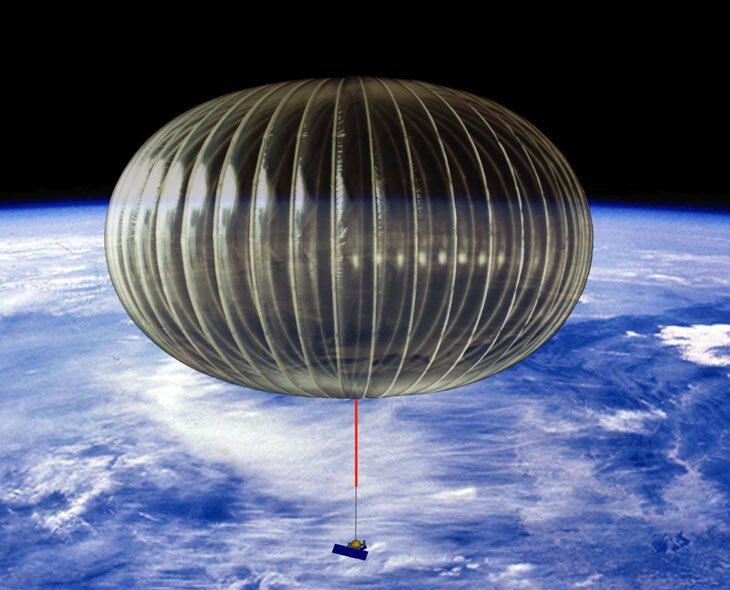
This project aims to develop a balloon system capable of providing scientific measurements for 100 day missions with floating altitudes close to 35 km transporting payloads of nearly 1.5 tons. The balloon is super-pressure made of a composite fabric that is filled with Helium and hermetically sealed. Meridional tendons provide additional rigidity to the envelope. The pressure inside the envelope is maintained above the ambient pressure at all times to keep the balloon afloat at a constant altitude.
NASA LWS SET project
Within the Living with a Star (LWS) program, the Space Environment Testbeds (SET) project performs flight and ground investigations. The SET project is aligned with the LWS goal of understanding how the Sun/Earth interactions affect humanity. The SET project is the element of the larger program that characterizes the space environment and its impact on hardware performance in space.
Hammers Company has supported the design, development, and testing of the flight software for the SET instrument systems on-board computer. Utilizing the ITOS command and control ground system, Hammers also supported SET integration and test. ITOS is planned for SET operations and support after launch